Rongai Route

Tanzania

6 Days Rongai Route

Duration:

6 Days

Tour Type:

Cultural Tourism

Transportation:

Private AC Van

Description:

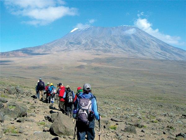
This route is considered one of the easiest and least crowded ways to climb Mount Kilimanjaro, offering a very high summit success rate. It begins on the northern side of the mountain, just south of the Kenyan border, providing a quieter and more remote trekking experience.

The descent follows the Marangu Route on the southern side of the mountain, allowing climbers to enjoy Kilimanjaro from a variety of scenic viewpoints along the way. The drive from Moshi to the trailhead takes approximately 2.5 hours, making access to the route convenient and straightforward.

Include/Not Include:

Tour Plan:

Day 1: Rongai Gate (1950m) - 1st Caves Camp (2600m)
Elevation (ft): 6,398 ft to 9,300 ft

Distance: 8 km/5 miles

Hiking time: 5 hours

Habitat: Montane Forest

After an early breakfast at your hotel, you will be picked up from Arusha (1400m) and driven to the Marangu Gate (1980m). Vehicle will pick you to the Rongai trail head (2.5 hours drive). The trail begins in the tall cornfields then leads into the pine forest. This trail has a gradual ascent and allows hikers to enjoy their surroundings. About halfway up the trail you will have a lunch break and you will reach the 1st Caves Camp (2600m) in the late afternoon or early evening. The porters and chef, who move very fast up the mountain, will reach camp before you and set up your tents, boil drinking water, and prepare snacks for your arrival. After washing up, a hot dinner will be served.
Elevation (ft): 9,300 ft to 11,300 ft

Distance: 6 km

Hiking time: 3-4 hours

Habitat: Moorlands

Following a hot breakfast, hikers will continue their ascent to kikelewa cave (3600m). The trail passes second cave (3450m) and this is a good spot to take a lunch break. Similar to the first night, your tents will be set up prior to arriving at camp and the porters will prepare drinking and washing water for you. Be prepared for a cold night as temperatures drop below freezing at this exposed camp.
Elevation (ft): 11,811 ft to 14,160 ft

Distance: 5 km/3.1 miles

Hiking time: 3-4 hours

Habitat: Moorlands

On this day, hikers will enjoy a short, yet steep trail to mawenzi tarn camp (4330m). In the moorland, you will spot exotic plants, including giant lobelia and groundsel. At camp, hikers will enjoy spectacular views and allow their bodies to acclimate. Hot dinner and washing water will be prepared for hikers as they enjoy the magnificent sunset.
Elevation (ft): 14,160 ft to 15,430 ft

Distance: 8 km

Hiking time: 4-5 hours

Habitat: Alpine desert

After breakfast, hikers will continue ascending east for a half-day hike to kibo hut. Kibo is located in the saddle which refers to the area located between the peaks of mawenzi and kibo in an alpine desert. An early dinner will be served so hikers can rest before attempting the summit the same night.

Your guide will brief you in detail on how to prepare for summit night. Get to sleep by 19:00!
Elevation (ft): 19,341 ft to 12,250 ft

Distance: 6km ascent and 21 km descent

Hiking time: 8 hours to uhuru and 6 hours to horombo

Habitat: Stone scree / ice-cap summit

Your guide will wake you around 23:30 for tea and biscuits. You will then begin your summit attempt. The trail is rocky up to hans meyer cave (5150m). You continue your ascent to gillman’s point (5681m). Reaching this section is an impressive achievement as the trail is steep, rocky, and at high altitude.

Gillman’s located on the crater rim. From this point, you will usually experience a snow covered trail until you reach the summit, uhuru peak (5895m). Reaching the summit of mt. Kilimanjaro is a lifetime accomplishment! You will be able to spend a short time on the summit taking photographs and drinking tea before the descent to barafu begins. The hike down to kibo hut takes about 3 hours.

At kibo hut, you will rest and enjoy a hot lunch in the sun. After eating, you will continue descending down to horombo hut (3720m). You will have a dinner, wash, and rest soundly at the hut after a strenuous day.
Elevation (ft): 12,139 ft to 6,003 ft

Distance: 27 km

Hiking time: 6 hours

Habitat: Rain forest

Following a well-deserved breakfast, your staff will have a big celebration full of dancing and singing. It is here on the mountain that you will present your tips to the guide, assistant guides, chef(s), and porters. After celebrating, you will descend for 6 hours back to marangu gate (1980m).

The national park requires all hikers to sign their names to receive certificates of completion. Hikers who reached gillman’s point (5681m) receive green certificates and hikers who reached uhuru peak (5895m) receive gold certificates. After receiving certificates, you will drive back to moshi/arusha for long overdue showers and celebrations.

Enquire Now

Number of travelers in your group